
GEOGEAR SUPPLY
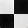
GeoGear 6 Pack (24"x24") Drone Ground Control Point GCP - UAV Aerial Drone Target for Aerial Mapping & Surveying | Grommet Pressed Black/White Checker | Pix4D & DroneDeploy | Visible from 400 Feet
41 858 Ft
69 763 Ft
-
 Order within 16 hours and 34 minutes to get between June 9 - June 15
 -
 Tracked Shipping on All Orders
-
 14-Day Returns
- Secure Payments
-
 24/7 Customer Support
Description
- GCP
- Ground control Target
- Point Cloud
- Aerial Mapping
24x24 AERIAL DRONE TARGETS - Ideal for drone mapping up to 400 feet, these GCPs are perfect for low to medium-altitude scans. The uniform size ensures accurate scaling during post-processing. CENTER EYELET FEATURE - This design lets users pinpoint the GCP's center using a survey rod without damage. It also aids in overlaying the target atop existing survey points for precise mapping. DURABLE YET LIGHTWEIGHT - Made of weather-resistant mesh, these targets are both visible and portable. The matte finish minimizes sunlight glare, ensuring ease during post-processing. SOFTWARE-FRIENDLY GCPs - With a checkerboard pattern, these GCPs are compatible with leading photogrammetry software. Notably, software that recognizes the checkerboard design pairs well. STABLE ANCHOR POINTS - Corner eyelets keep these targets in place during scans. They can remain outdoors for extended periods, guaranteeing consistent data for multiple drone flights. INDUSTRY-APPROVED - From surveying and construction to scene reconstruction, these UAV GCPs are widely adopted, even in academic training. COST-EFFICIENT TARGETS - Often, our GCPs prove to be more economical and better designed than DIY alternatives. 400-FOOT VISIBILITY - Recognizable from 400 feet, they're compatible with a broad spectrum of drones in the aerial survey sector. SLIM DESIGN - The thin profile lets you measure directly atop the GCPs, eliminating potential errors and streamlining your mapping endeavors. CLIMATE-READY - The mesh material ensures rapid drying from moisture and allows snow to melt through, making them suitable for diverse weather conditions.
Shipping and Returns
- We offer tracked shipping on all orders. Tracking information will be shared as soon as the order is dispatched.
- Please check the delivery estimate before adding a product to the cart. This is displayed for every product on the website.
- Available shipping methods and charges will be displayed at the time of checkout, depending on your exact location.
- All customers are entitled to a return window of 14 days, starting from the date of delivery of the product(s).
- Customers are advised to read our return policy for details of the return process, eligibility, refunds as well as cancellations or exchanges.
- In case of any issues or concerns about Shipping or Returns, please contact us and we will be happy to help.
GeoGear Supply.
GeoGear 6 Pack (24"x24") Drone Ground Control Point GCP -...
41 858 Ft
69 763 Ft